Integrating AutoCAD with GIS for Enhanced Substation Design
In the realm of substation design, precision, accuracy, and seamless collaboration are paramount. Engineers and designers are continually seeking innovative ways to streamline the design process while ensuring that the final product meets safety, efficiency, and regulatory standards. One such innovation is the integration of AutoCAD with Geographic Information Systems (GIS) – a dynamic duo that enhances substation AutoCAD design and management. In this blog, we will explore the benefits and applications of integrating AutoCAD with GIS in the context of substation design, highlighting how this synergy elevates the industry.
The Power of Substation AutoCAD
Before delving into the integration of AutoCAD with GIS, let’s understand why AutoCAD holds a prominent position in substation design:
- Precision and Detail: AutoCAD provides a robust platform for creating precise, detailed drawings and layouts. It is widely used in the field of engineering due to its accuracy and flexibility.
- Familiarity: AutoCAD is a familiar tool for many engineers and designers. Its user-friendly interface allows professionals to work comfortably and efficiently.
- Customization: AutoCAD offers extensive customization options, allowing designers to tailor their drawings to specific project requirements. This adaptability is crucial in substation design.
- 3D Modeling: AutoCAD’s 3D modeling capabilities enable designers to create intricate substation layouts that account for spatial constraints and equipment placement.
The GIS Advantage
Geographic Information Systems (GIS) is a technology that captures, stores, analyzes, and manages geographic data. When integrated with AutoCAD, it offers several advantages:
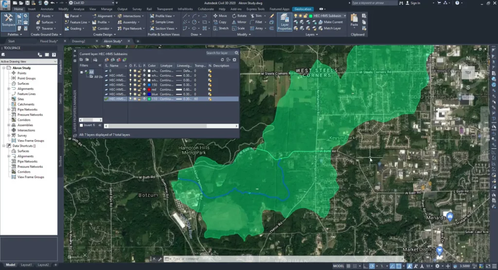
- Spatial Awareness: GIS provides valuable spatial context. Engineers can overlay substation design plans onto geographic maps, allowing them to visualize how the substation fits into the surrounding environment.
- Data Integration: GIS integrates various data sources, such as terrain data, land parcel information, and infrastructure data. This enables engineers to make informed decisions during the design process.
- Asset Management: GIS helps in tracking and managing substation assets efficiently. It provides a holistic view of the substation’s components, making maintenance and inspections more effective.
- Environmental Impact Assessment: GIS can aid in assessing the environmental impact of substation construction and operations, helping companies meet regulatory requirements.
Benefits of AutoCAD-GIS Integration in Substation Design
Now, let’s explore how the integration of AutoCAD with GIS enhances substation design:
1. Accurate Geospatial Data: By overlaying AutoCAD drawings onto GIS maps, engineers can ensure that substation designs are aligned with the geographical and environmental context. This reduces the risk of errors due to misalignment.
2. Data Collaboration: AutoCAD-GIS integration facilitates seamless data sharing and collaboration among project stakeholders. Engineers, GIS specialists, and environmental experts can work together effectively, leading to better-informed design decisions.
3. Visual Context: The combination of AutoCAD’s detailed drawings and GIS’s mapping capabilities provides a visual context that helps engineers assess how the substation design interacts with the landscape, nearby infrastructure, and potential environmental concerns.
4. Efficient Asset Management: GIS helps in tracking and managing substation assets, simplifying maintenance and reducing downtime. Engineers can pinpoint the location of specific equipment and access relevant data quickly.
5. Regulatory Compliance: Integration with GIS assists in meeting regulatory requirements, especially regarding environmental impact assessments and land use considerations. This ensures that substation designs adhere to legal and environmental standards.
Application Examples
Here are a few examples of how AutoCAD-GIS integration can be applied in substation design:
- Site Selection: GIS data can be used to identify suitable locations for new substations by analyzing factors like land use, accessibility, and environmental impact.
- Environmental Impact Assessment: Engineers can use GIS to assess the environmental impact of substation construction and operation, ensuring compliance with regulations.
- Asset Management: GIS can be employed for efficient asset management, allowing engineers to monitor equipment status, maintenance schedules, and equipment history.
- Emergency Response: In case of emergencies or maintenance issues, GIS data can help first responders locate substations quickly and safely.
Embracing a Brighter Future for Substation Design
The integration of AutoCAD with GIS is revolutionizing substation design by enhancing precision, collaboration, and environmental considerations. As the demand for reliable and sustainable energy continues to grow, this synergy between design software and geospatial data management is poised to play a pivotal role in shaping the future of the substation design industry. It offers engineers the tools they need to create safer, more efficient, and environmentally responsible substations for our evolving world.